By Sam Storr/CIMMYT
Remote sensing experts, breeders, agronomists and policymakers discussed turning their research and experiences into tools to benefit farmers and increase food production while safeguarding the environment during CIMMYT’s workshop “Remote Sensing: Beyond Images” from 14-15 December 2013.
The event was sponsored by the Bill & Melinda Gates Foundation (BMGF), the Mexican Secretariat of Agriculture, Livestock, Rural Development, Fisheries and Food (SAGARPA) and the Sustainable Modernization of Traditional Agriculture (MasAgro) as well as the CGIAR Research Program on Maize and the Cereal Systems Initiative for South Asia (CSISA).
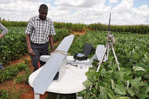
Remote sensing devices make it possible to observe the dynamics of anything from single plants up to entire landscapes and continents as they change over time by capturing radiation from across the entire electromagnetic spectrum. For example, images taken by cameras in the thermal-to-visible end of the spectrum can reveal a broad range of plant characteristics, such as biomass, water use and photosynthesis efficiency, disease spread and nutrient content. Radar or light radar (LiDAR) imaging can be used to create detailed imaging of plant physical structure from the canopy down to the roots. When mounted on an unmanned aerial vehicle (UAV), these sensors can rapidly survey much greater areas of land than is possible from the ground, particularly in inaccessible areas. It is hoped that such research will complement highthroughput phenotyping, opening the way for plant breeders to design larger and more efficient crop improvement experiments.
For agronomy research, remote sensing can provide new information about weather, crop performance, resource use and the improved genetic traits sought by crop breeders. It may also help global agriculture meet the challenge of achieving more with fewer resources and include more farmers in innovation. If methods can be found to share and connect this data, farmers will also benefit from greater transparency and more informed policymaking.
Opening the workshop, Thomas Lumpkin, CIMMYT director general, reminded participants of the urgency of meeting the growing demand for staple crops while overcoming crop diseases, resource scarcity and climate change-induced stresses. The advance of technologies and data processing tools allows researchers to see the potential contribution of remote sensing. “For thirty years, the remote sensing community has been on the cusp of doing something wonderful, and now we believe it can,” said Stanley Wood, senior program officer for BMGF. “What excites us is the amount of energy and enthusiasm and the knowledge that their work is important.” Several presentations showcased how remote sensing can be used to benefit smallholder farmers. For example, the Drought Tolerant Maize for Africa (DTMA) project is looking at using rainfall data to target its interventions for the greatest impact.
Bruno Gérard, director of CIMMYT’s Conservation Agriculture Program, spoke about the challenges of CIMMYT’s work in helping smallholder farmers to practice “more precise agriculture.” The spread of mobile phones and information and communications technologies (ICTs) in the developing world shows the potential for CIMMYT to bring recommendations derived from remote sensing to farmers and allows them to provide their own input. The workshop ended with a panel discussion on how to develop remote sensing services that will be adopted by intended users. Participants expect the workshop and similar activities will provide the strategic direction to drive a new generation of remote sensing applications that can bring real benefits to farmers.
For more information on the program, abstracts, participants and presentations, visit the MAIZE website.
 Climate adaptation and mitigation