With funding from MAIZE and WHEAT CRPs, the Global Conservation Agriculture Program acquired a new remote sensing system consisting of a multispectral and a thermal camera, software, and methods allowing for semi-automated image processing. The two cameras were delivered in February by Pablo J. Zarco- Tejada, director of QuantaLab remote sensing laboratory, Instituto de Agricultura Sostenible (IAS), Consejo Superior de Investigaciones Científicas (CSIC), Córdoba, Spain. Zarco-Tejada along with three technicians spent several days at CIMMYT-Obregón to train a pilot and CIMMYT staff on the equipment use.
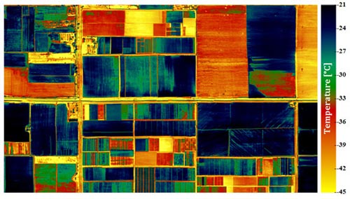
The thermal camera helps to measure a water stress indicator: plant canopy temperature. Plants under water stress close their stomata to reduce transpiration, which increases crop canopy temperature as a result of reduction in evaporative cooling. Consequently, temperature differences between well-watered and water-stressed plants can be used to detect water stress accurately and at early stages. This will be used by MasAgro to measure the impact of tillage on crop water use efficiency, but it will also enable CIMMYT to develop a diagnostic tool based on the Crop Water Stress Index to help farmers determine the right time to irrigate wheat in the Yaqui Valley, Mexico. Once validated, the Crop Water Stress Index may also serve to identify the best time to irrigate plots at the research station.
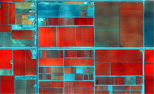
The multispectral camera measures the light reflected in green, red, and near-infrared ranges. While a dense plant canopy can absorb more than 95% of the light in the visible range (violet to red), it reflects most of the light in the near-infrared range. Information on the light reflectance in the visible and near-infrared ranges helps to estimate ground cover and leaf area index, parameters usually correlated with biomass and yield. With two spectral channels in the red-edge region (in between the red and near-infrared ranges), the camera also allows to estimate the canopy chlorophyll content or greenness. Chlorophyll content is closely related to the nitrogen status of the crop, but it can be used to detect other nutrient deficiencies as well. Furthermore, the potential of using the multispectral camera in an airplane as a ‘flying GreenSeeker’ could enable researchers to diagnose nitrogen needs to optimize yield for around 1,000 hectares in about 1 hour, at a resolution of about 4 meters.
Within a few weeks, a hyperspectral camera will be added to the system. This camera with a spectral range between 400-1,000 nanometers is capable of acquiring 320 spectral bands and can be used to obtain images at a resolution as fine as 0.20 meters. It will be used to study the potential of the multispectral and hyperspectral sensors mounted on an airplane to diagnose nitrogen status and derive nitrogen recommendations to improve wheat quality (high protein content, low percentage of yellow berry, etc.). The hyperspectral imager also enables stress detection using other narrow-band vegetation indices related to the light-use efficiency, such as photochemical indicators, and quantification of chlorophyll fluorescence related to the canopy photosynthesis. Since all sensors can be mounted on the airplane simultaneously, it may be possible to diagnose irrigation and nitrogen fertilization needs during one flight. Thus researchers can develop diagnostic tools and recommendations for in-season nitrogen and water management to achieve higher nitrogen and water use efficiency.
The multispectral and thermal cameras are fully operational and will cover the research station in Obregón on a weekly basis until the end of April, with the resolution ranging between 0.20 and 0.40 meters, depending on the flight altitude and the type of camera. This is detailed enough to identify individual plots.
The collaboration between CIMMYT and QuantaLab-IAS-CSIC will continue through the setup of the new hyperspectral camera, further research conducted on crop stress indicators, and the identification of successful remote sensing indices. Canopy temperature, normalized difference vegetation index, and other vegetative indices will be made available at minor cost to all interested scientists. These measurements could be used for phenotyping, physiological, and agronomic research.
 Climate adaptation and mitigation