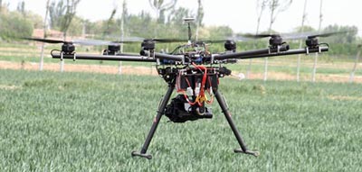
MKII Canon SLR Visual Camera flying over winter wheat
near Wuzhong City, China. Photo: Jack McHugh/CIMMYT
We have come a long way when it comes to obtaining aerial images of our research sites. My colleagues and I once used helium-filled balloons and twin cameras to obtain infrared and color images in an all-day operation; now we use unmanned aerial vehicles (UAVs) fitted with high-resolution lenses and multispectral cameras to take dozens of images over large areas in a matter of minutes.
Farmers and researchers need to know every square meter of their fields, to determine spatial variability, take remedial action and implement adaptive controls and responses. UAVs can achieve this without anyone setting foot in the field. In an era where we are time- and resource-poor, we can accurately assess the health of entire fields in mere minutes, which could have an enormous impact on agriculture.
However, in Northwestern China, the notion of using UAVs to take aerial pictures in an agricultural setting evokes suspicion, elicits numerous questions and is extremely novel.
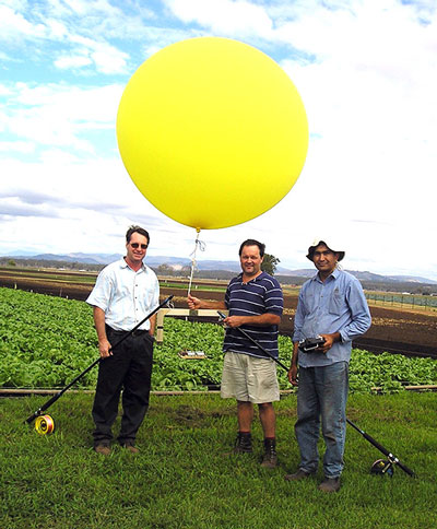
Amjed Hussain of the University of Southern
Queensland, utilizing a helium-filled balloon
for aerial imagery of a cabbage research trial
in SE Queensland. Photo: Troy Jensen
As a result, we have to provide detailed explanations and gain permission from a number of local authorities before we can undertake what is a simple non-invasive task that would normally go unnoticed on a farm in Australia or Mexico.
CIMMYT-China’s Global Conservation Agriculture Program (GCAP) and the Ningxia Academy of Agricultural Sciences obtained permission from the Wuzhong City Agricultural Mechanization Bureau to fly a UAV. Earlier this month, my colleague Mr. Zhang Xuejian, Director of the Information Research Institute, enlisted a local UAV operator to take images of conservation agriculture, relay cropping and wheat variety trials at a demonstration site near Wuzhong City in Ningxia Hui Autonomous Region.
Although the Information Research Institute has a fixed-wing UAV with sophisticated imagery equipment, the system is somewhat dated and requires extensive documentation, a landing strip and up to six operators. However, the GCAP-Ningxia Academy of Agricultural Sciences collaboration recently demonstrated the flexibility, capability and efficiency of a modern, multi-rotary wing UAV that rapidly produces imagery and readily displays agronomic traits, farm management and genetic responses not easily appreciated or identified at ground level. Given the success of this demonstration, we will seek funding to buy a new aircraft and develop proximal sensing and imagery within the region.
Smallholder farmers need accurate, inexpensive, readily-available data to increase production, but have traditionally not had access to precise spatial information due to time, money and labor constraints. UAVs can collect visual, thermal and hyperspectral data, which when analyzed provide a broad range of information that would otherwise be unavailable. UAV imagery can also focus on specific biotic and abiotic issues such as diseases, crop stress and farm management. UAV technology would provide breeders and agronomists in NW China not only a new view of agriculture, but also a new path to achieving increased production and food security, while conserving natural and human resources.
 Capacity development