NEW DELHI — The International Maize and Wheat Improvement Center (CIMMYT) has launched the beta version of the Landscape-scale Crop Assessment Tool (LCAT), a geo-informatics technology that will help scientists to forecast crop yields and identify regions where conditions will support the adoption of specific technologies. Using geo-informatics, the Cereal Systems Initiative for South Asia (CSISA), for example, was able to identify districts in the state of Odisha most prone to flooding and categorize them as areas ill-suited for direct seeded rice. LCAT will provide a platform for extension professionals, policymakers and research scientists to leverage geo-informatics for better decision-making. The tool was developed for South Asia but can be used globally.
“In the eastern Indo-Gangetic Plains, we promote early sowing of wheat, which is one of the most important adaptations to climate change. But we haven’t been able to accurately monitor and measure where it is being implemented and when,” explained Andrew McDonald, CIMMYT principal scientist and CSISA project leader. “In our line of work, it is crucial to understand where you’re making progress. While the data exists, it is often not integrated at the spatial level.”
Considerable environmental and man-made landscape diversity exists across South Asia. LCAT will help to analyze these landscapes and characterize large areas of land based on remote sensing data. It will serve two main purposes – to facilitate technology targeting and provide information such as crop status, phenology and yield goals to support crop management decisions.
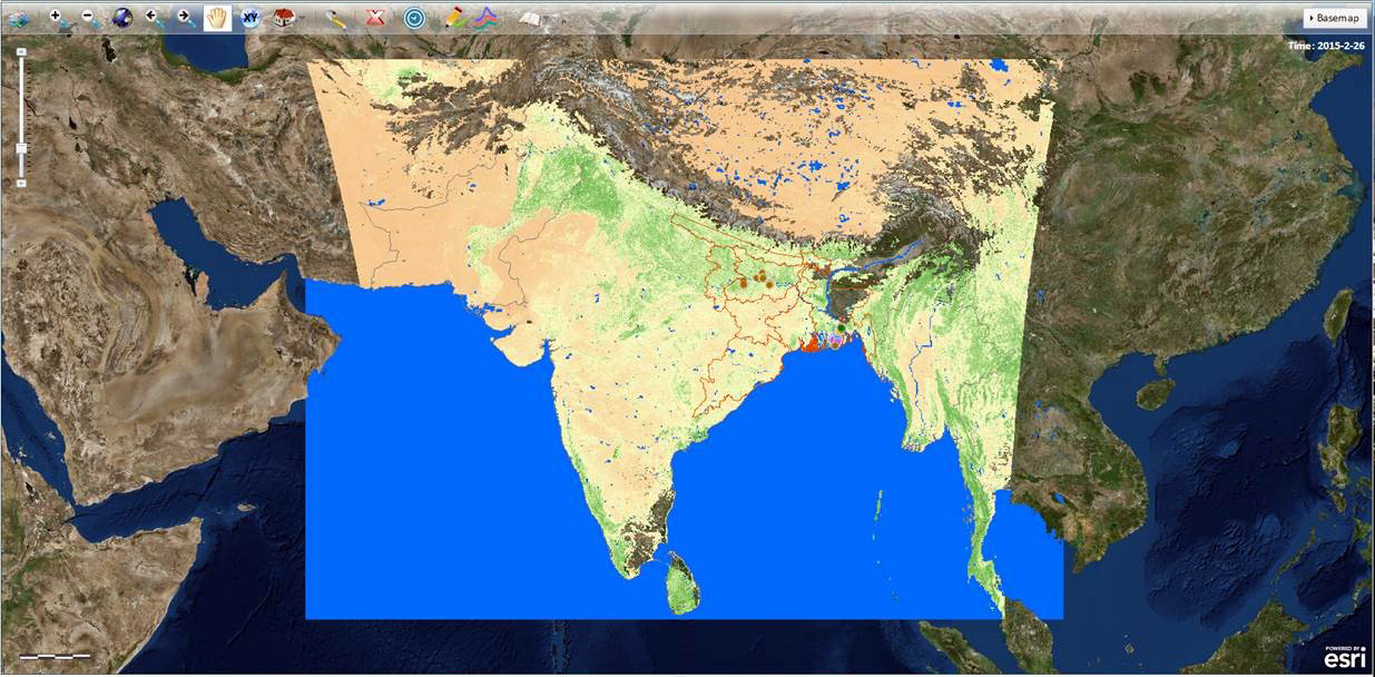
“The first version of the tool uses datasets from CSISA sites in Bangladesh and India to characterize the existing cropland. However, the algorithms on which it is based are generic and can hence be applied to describe any dominant agricultural landscape across the globe,” said Balwinder Singh, CIMMYT crop simulation modeler. “Within CSISA, the tool will be used for specific applications extending to crop yield forecasting and monitoring, learning and evaluation.”
However, critical knowledge gaps between landscape-scale processes and technology targeting remain a challenge. To ensure policymakers and scientists are able to effectively collaborate in using this tool, a team of scientists from Oak Ridge National Laboratories (ORNL) visited New Delhi in May to conduct a training session on LCAT for CSISA staff and government partners from India and Bangladesh. The training not only demonstrated the tool’s beta version but also created greater understanding of its practical applications.
“If you’re a user of data, you spend 60 percent of your time just assembling data before analyzing it. We want to reduce that to 5 percent,” said Suresh Vannan, director of the ORNL Distributed Active Archive Center for Biogeochemical Dynamics and CCSI data theme leader.
LCAT is being developed in collaboration with ORNL and the Group on Earth Observations Global Agricultural Monitoring (GEOGLAM) Initiative. It is funded by CIMMYT as part of a five-year agreement with ORNL signed in 2014.

 Nutrition, health and food security